
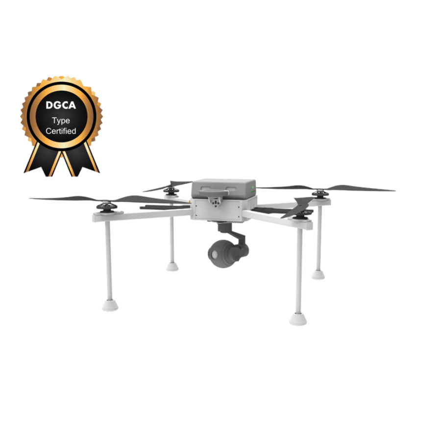
UMT HAWK4G SURVEY DRONE - DGCA Type Certified
- DGCA-type certified UAV
- Advanced drone solutions for aerial surveying
- Reliable and accurate data collection
- Ideal for mapping, agriculture,
- Infrastructure inspection and environmental monitoring
- Robust construction for durability
- Trusted by professionals worldwide
- Trusted dealerDirect manufacturer partnership
- Pan-India deliveryInsured shipping, all states
- Post-sale supportTraining + service included
What makes it work
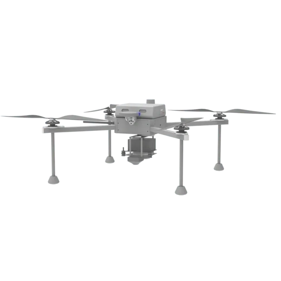
UMT HAWK4G SURVEY DRONE
The UMT Hawk4G Survey Drone represents a significant leap forward in the field of aerial survey technology. It’s not just an ordinary drone; it’s a highly sophisticated, DGCA type-certified aerial device designed to deliver top-notch accuracy and efficiency in data collection. This drone is equipped with advanced 4G connectivity, high-resolution imaging capabilities, and an extended flight duration, making it an indispensable tool for professionals in agriculture, construction, environmental monitoring, and many other sectors.
Features of UMT HAWK4G SURVEY DRONE
DGCA Type Certification: The UMT Hawk4G has achieved the esteemed Directorate General of Civil Aviation (DGCA) type certification, ensuring it meets the highest standards of safety and operational efficiency. This certification allows for legal and compliant use in various commercial applications, setting a benchmark in drone safety and reliability.
Advanced 4G LTE Connectivity: Unlike traditional drones that depend on Wi-Fi or radio frequencies, the UMT Hawk4G utilizes advanced 4G LTE connectivity. This feature enables real-time data transmission over long distances and ensures stable communication between the drone and its control station, facilitating seamless operations even in remote or challenging environments.
High-Resolution Imaging System: Equipped with state-of-the-art cameras, the UMT Hawk4G captures high-resolution images and video footage. This capability is crucial for detailed surveying and mapping, allowing for the collection of precise and clear visual data for analysis and decision-making.
Extended Flight Duration: The drone is designed for prolonged flight times, significantly surpassing the average duration offered by other drones. This extended flight capability allows users to cover more ground in a single operation, enhancing efficiency and productivity for large-scale projects.
Robust Design and Construction: The UMT Hawk4G features a robust design that ensures durability and resilience in various operating conditions. Its construction is optimized for both performance and reliability, making it suitable for demanding surveying tasks across different terrains and environments.
Precision Navigation and Flight Control: With advanced navigation systems, the UMT Hawk4G offers superior flight control and precision. It is capable of executing complex flight paths and maneuvers, ensuring accurate data collection and efficient surveying operations.
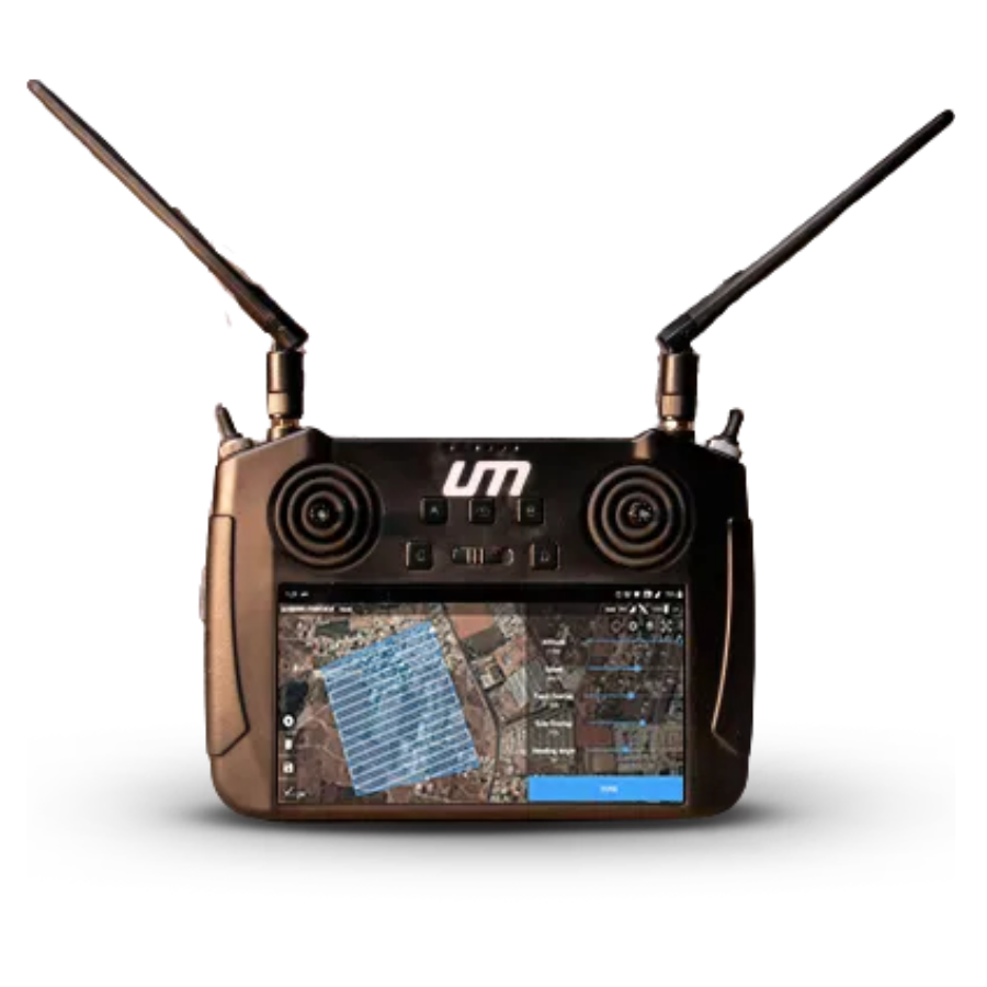
User-Friendly Interface: The drone is designed with a user-friendly interface, making it accessible to operators of varying skill levels. Its intuitive control system simplifies the complexities of drone operation, allowing for easy management of flight paths, data collection, and real-time monitoring.
Versatile Application Use: The UMT Hawk4G is not limited to a single industry; it’s versatile enough to be used in agriculture for crop monitoring, in construction for site surveying, in environmental conservation for monitoring changes, and in many other fields requiring aerial data collection.
Customizable Payload Options: To cater to different surveying needs, the UMT Hawk4G allows for customizable payload options. Users can equip the drone with various sensors and cameras depending on the specific requirements of their surveying tasks, making it a flexible tool for a wide range of applications.
Safety Features: The drone includes several safety features, such as automatic return-to-home on loss of signal, geofencing to prevent entering restricted areas, and obstacle avoidance systems. These features ensure the safety of the drone during flight, protecting both the drone and its surroundings.
Compliance with Global Standards: Beyond DGCA certification, the UMT Hawk4G is designed to comply with global aviation standards, making it suitable for use in many countries around the world. This compliance assures users of its quality and international acceptability.
ABOUT UMT HAWK4G SURVEY DRONE
Our comprehensive surveying solution is the Hawk4G Survey. This unmanned aerial vehicle (UAV) can survey hundreds of acres in a single flight, saving both time and money compared to traditional surveying techniques. Drone surveying is quick and easy with the UMT Sparrow PPK working in tandem with our GCS, the UMT Launch Pad.
3.2 Kgs
40-59 Mins
1.7 GSD Accuracy
Max Speed: 54 kmph
315 Acres Per Flight
Single-pilot operation

Service Ceiling: 2000m AMSL

Max Wind Resistance: 54 kmph

FLIR Thermal Camera

24/32/40 MP Day Camera

LiDAR Sensor (Coming Soon)

Plan and execute a mission in 35 s

No training required

Single-click geofencing capabilities
DGCA Type Certification Explained: DGCA-type certification is a testament to the UMT Hawk4G’s adherence to the highest standards of safety and operational efficiency. This certification indicates that the drone has undergone rigorous testing and evaluation by the Directorate General of Civil Aviation, ensuring it meets the stringent requirements for commercial operation in various industries. For users, this means enhanced reliability, safety, and compliance with national aviation regulations.
Unique Features of UMT Hawk4G (Advanced 4G Connectivity): One of the standout features of the UMT Hawk4G is its advanced 4G LTE connectivity, enabling real-time data transmission over long distances without the need for Wi-Fi or radio frequency signals. This ensures uninterrupted communication between the drone and its operator, facilitating seamless data collection and transmission.
High-Resolution Imaging Capabilities: Equipped with state-of-the-art cameras, the UMT Hawk4G captures high-resolution images and videos, providing detailed aerial views for accurate surveying and mapping. This capability is crucial for industries requiring precise measurements and detailed visual documentation of landscapes, infrastructure, and project sites.
Extended Flight Time: The UMT Hawk4G is designed for endurance, offering an extended flight time compared to conventional drones. This allows users to cover larger areas in a single flight, significantly increasing productivity and reducing the need for frequent landings and battery changes.
Applications in Various Industries: The versatility of the UMT Hawk4G makes it an invaluable asset in a wide range of applications. In agriculture, it can be used for crop monitoring, pest control, and precision farming. In construction, it aids in site surveying, progress monitoring, and asset management. Environmental monitoring also benefits from the drone’s capabilities, including wildlife tracking, forest management, and pollution assessment.
Operational Excellence (Ease of Use): Despite its advanced features, the UMT Hawk4G is designed with user-friendliness in mind. Its intuitive control system and user-friendly interface ensure that operators can easily manage the drone, regardless of their level of experience.
Precision and Accuracy: Accuracy is paramount in surveying and mapping, and the UMT Hawk4G excels in this area. Its precision navigation systems and high-quality imaging ensure that the data collected is accurate and reliable, enabling users to make informed decisions based on precise information.
User Experience and Testimonials: Users of the UMT Hawk4G frequently praise its reliability, ease of use, and the quality of data it provides. Testimonials from various industries highlight how the drone has revolutionized their operations, offering insights and efficiency improvements that were previously unattainable.
Maintenance and Support: UMT provides comprehensive maintenance and support services for the Hawk4G, ensuring that users can rely on the drone for their critical surveying needs over the long term. From detailed maintenance manuals to responsive customer service, UMT has users covered.
Comparison with Competing Drones: When compared to other drones in the market, the UMT Hawk4G stands out for its regulatory compliance, advanced features, and operational efficiency. A detailed comparison reveals how the Hawk4G offers superior value in terms of performance, reliability, and support.
Regulatory Compliance and Safety: Safety and compliance with regulatory standards are at the forefront of the UMT Hawk4G’s design. Its DGCA certification is complemented by built-in safety features, ensuring safe operations in diverse environments and compliance with global aviation standards.
Purchasing and Financing Options: Acquiring the UMT Hawk4G is made easy with a variety of purchasing and financing options available to suit different budgets and requirements. UMT’s sales team is ready to assist customers in finding the best solution for their needs.
Conclusion: The UMT Hawk4G Survey Drone is a remarkable tool that combines advanced technology, regulatory compliance, and user-centric design to offer unmatched capabilities in aerial surveying. Whether for agriculture, construction, or environmental monitoring, the Hawk4G is a reliable, efficient, and indispensable asset for professionals looking to leverage the power of aerial data.
Specifications of UMT HAWK4G SURVEY DRONE
General
UMT HAWK4G SURVEY DRONE
Model: UMT Hawk4G
Certification: DGCA Type Certified for compliance with aviation safety and operational standards.
Weight: 2.5 kg (without payload)
Dimensions: 60 cm x 60 cm x 30 cm
Material: High-strength composite materials for durability and lightweight performance.
Performance
Flight Time: Up to 45 minutes on a single charge, enabling extended operations over large areas.
Maximum Speed: 60 km/h, suitable for efficient surveying and rapid transit between locations.
Maximum Altitude: Up to 5000 meters above sea level, offering versatility in various geographical settings.
Wind Resistance: Up to 20 knots, ensuring stable operation in challenging weather conditions.
Connectivity and Communication:
UMT HAWK4G SURVEY DRONE
Connectivity: Advanced 4G LTE for real-time data transmission and control over long distances.
Control Range: Up to 10 kilometers, allowing for extensive area coverage.
Data Link: Secure and encrypted communication channels to ensure data integrity and privacy.
Imaging and Sensors:
Camera: High-resolution 20 MP camera with zoom capabilities for detailed imaging.
Video Resolution: 4K at 30fps, providing crisp and clear aerial footage.
Sensor Compatibility: Customizable payload options to accommodate various sensors for specific surveying needs (e.g., thermal, multispectral, LiDAR).
FAQs on UMT HAWK4G Survey Drone - DGCA Type Certified
- What makes the UMT HAWK4G Drone unique? The UMT HAWK4G stands out for its DGCA Type Certification, advanced surveying capabilities, and comprehensive safety features, setting a new standard in drone technology.
- How does DGCA Type Certification benefit users? This certification ensures the drone meets rigorous safety and performance standards, providing users with assurance of its reliability and compliance with regulatory requirements.
- Can the UMT HAWK4G be used in commercial surveying? Absolutely. Its precision, efficiency, and certification make it an ideal tool for a wide range of commercial surveying applications.
- What industries can benefit from the UMT HAWK4G? Industries such as agriculture, construction, and emergency response can greatly benefit from the drone’s advanced surveying capabilities.
- Is training required to operate the UMT HAWK4G? Yes, to fully leverage the drone’s capabilities and comply with regulations, operators should undergo certified training programs.
- What maintenance does the UMT HAWK4G require? Regular maintenance includes routine checks and following best practices to ensure the drone’s longevity and optimal performance.
The full sheet
Related products
-
·AIR·00
Out of stock
 DJI Mini 3 Pro Drone Camera With Smart Controller (Standard Pack)Original price was: ₹123,810.₹77,143Current price is: ₹77,143. (Excl. GST)Notify me
 -
·AIR·01
-
·AIR·02
Out of stock

 DJI Mavic 3 Standard Drone CameraOriginal price was: ₹261,905.₹226,162Current price is: ₹226,162. (Excl. GST)Notify me
 -
·AIR·03

There are no reviews yet.