

Parrot Anafi USA GOV Edition Drone
- Optional altitude fencing & geofencing
- No take-off temperature limitation
- Disable all onboard logs for absolute data security
- Activate the most powerful available Wi-Fi bandwidths anywhere in the world
- Disable auto-RTH function for complete control over full flight
- Import additional map formats for enhanced tactical awareness
- Trusted dealerDirect manufacturer partnership
- Pan-India deliveryInsured shipping, all states
- Post-sale supportTraining + service included
What makes it work
ANAFI USA GOV EDITION
A robust and adaptable drone designed for professional and government use is the Parrot ANAFI USA Gov Edition. First responders, law enforcement, and government agencies have high standards, and it satisfies them thanks to its secure data transmission, advanced imaging capabilities, and sturdy architecture. With its 32x zoom, infrared imaging, and 4K HDR video recording, it provides outstanding situational awareness and intelligence-gathering capabilities. With its encrypted communications and tough construction, the ANAFI USA Gov Edition guarantees dependable performance and data security in mission-critical situations.
The Parrot Anafi USA GOV Edition Drone is a high-performance UAV designed for government agencies, featuring advanced security, durability, and imaging capabilities. Its notable features include:
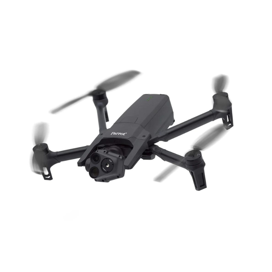
Portability and Design: Weighing just 500g (1.1lbs) and featuring a foldable design for easy transport and rapid deployment. Its compact size does not compromise its 32-minute flight time, making it exceptionally portable and efficient.
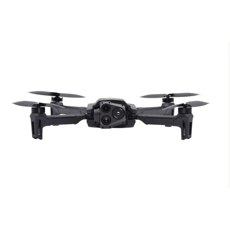
Advanced Imaging System: Equipped with three cameras, including a FLIR Boson thermal camera, a 32x zoom RGB camera, and a wide-angle RGB camera, to produce clear, non-pixelated images and videos. The gimbal and optics are designed for detailed observation from distances up to 5 km (3.1 miles), with the ability to detect centimetric hot spots on targets like solar panels from an altitude of 40m (44 yards).
Security Features: The drone prioritizes security with AES-XTS SD card encryption using a 512-bit key, secure WPA2 Wi-Fi connections, digitally signed firmware, and compliance with GDPR for data privacy and security. It ensures that no data is shared by default, with optional data sharing through the FreeFlight 6 app.
Sensors and Navigation: It’s equipped with GPS, GLONASS, and GALILEO for satellite navigation, along with a barometer, magnetometer, vertical camera, ultra-sonar, 6-axis IMU, 3-axis accelerometers, and gyroscopes for precise positioning and stabilization.
Thermal and Visual Sensors: The drone features built-in cameras for 4K visual, thermal, or blended views, allowing real-time switching between modes for optimal observation and reconnaissance. It includes a telephoto EO sensor with a 32X digital zoom and a wide EO sensor with a 110° DFOV, along with a FLIR BOSON 320 IR sensor for thermal imaging.
Durable and Powerful: Designed to operate in a wide range of environments, it can withstand extreme temperatures from -32° to 110°F, resist winds up to 32.8 miles per hour, and is IP53-certified against dust and rain.
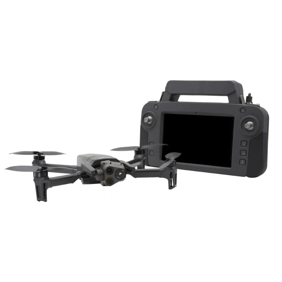
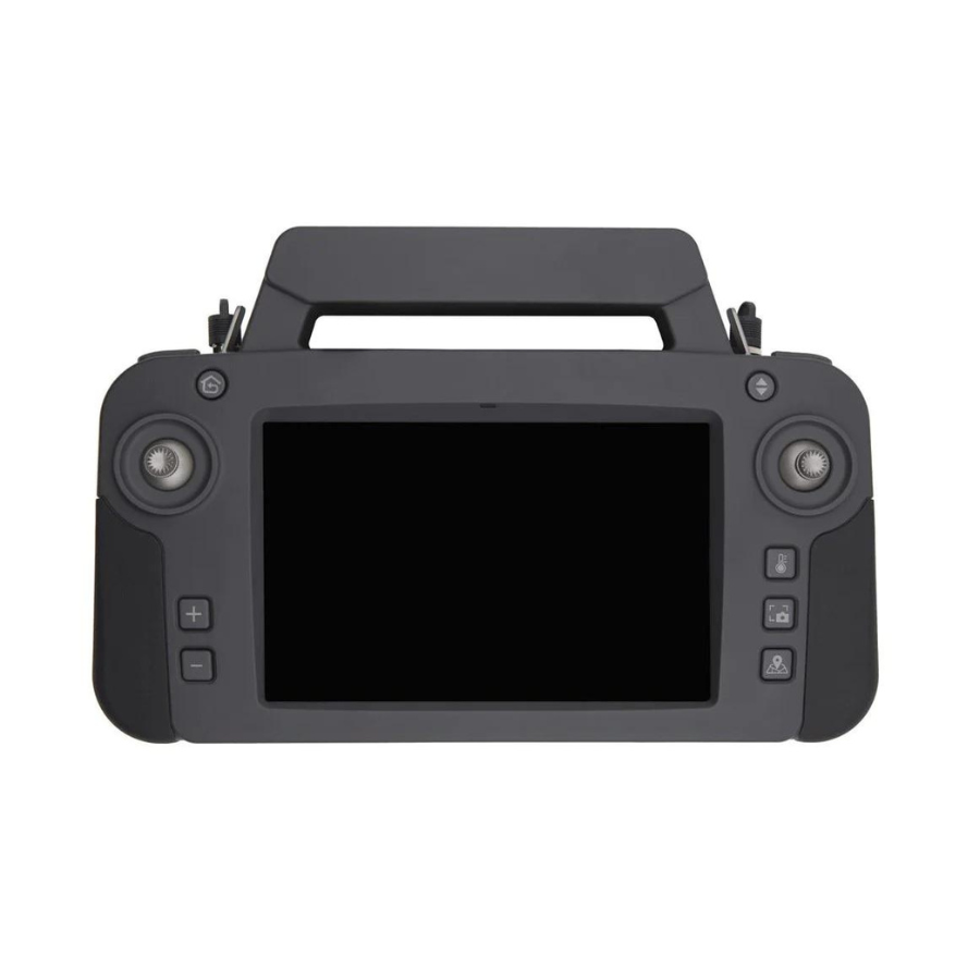
Smart Controller and Software Ecosystem: Comes with the Skycontroller USA, featuring a bright eight-inch touchscreen display with FreeFlight 6 piloting software. It supports a range of professional applications and services through its open-source SDK and industry-standard protocols. Compatible with Pix4Dreact for quick transformation of images into precise 2D maps
PARROT ANAFI USA GOV EDITION
A DRONE DESIGNED FOR GOVERNMENT AGENCIES
Produced in the United States, ANAFI USA has the same superior imaging, durability, and security features as Parrot’s Short-Range Reconnaissance (SRR) drone, which was created for the US Army. Offering top-notch privacy and security for sensitive missions, ANAFI USA’s data encryption and privacy features comply with the General Data Protection Regulation (GDPR) of the European Union.
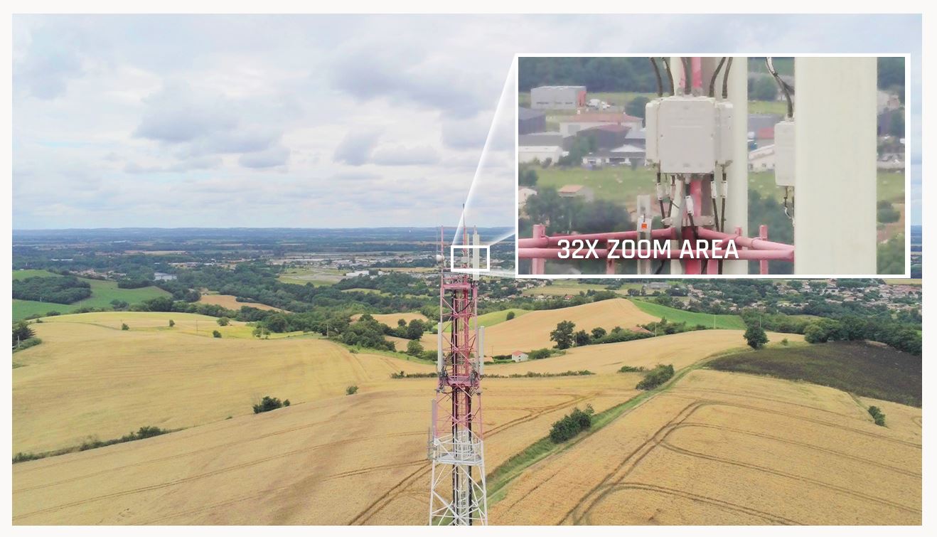
X32 Zoom Thermal Image Stabilization | 4K Visual Excellence
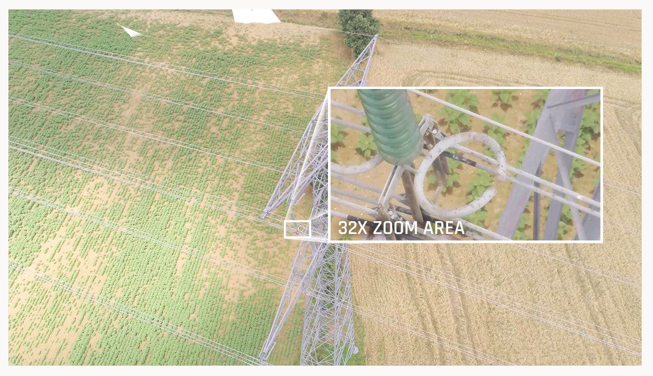
The most crucial task for firefighters when they get to a fire site is to observe hot spots and evaluate the complete visual scene. This problem was considered in the design of ANAFI USA’s sophisticated optics and gimbal. With the help of the 32x zoom, which is built around two 21-megapixel cameras, users can see fine details up to 5 kilometers (3.1 km) away.
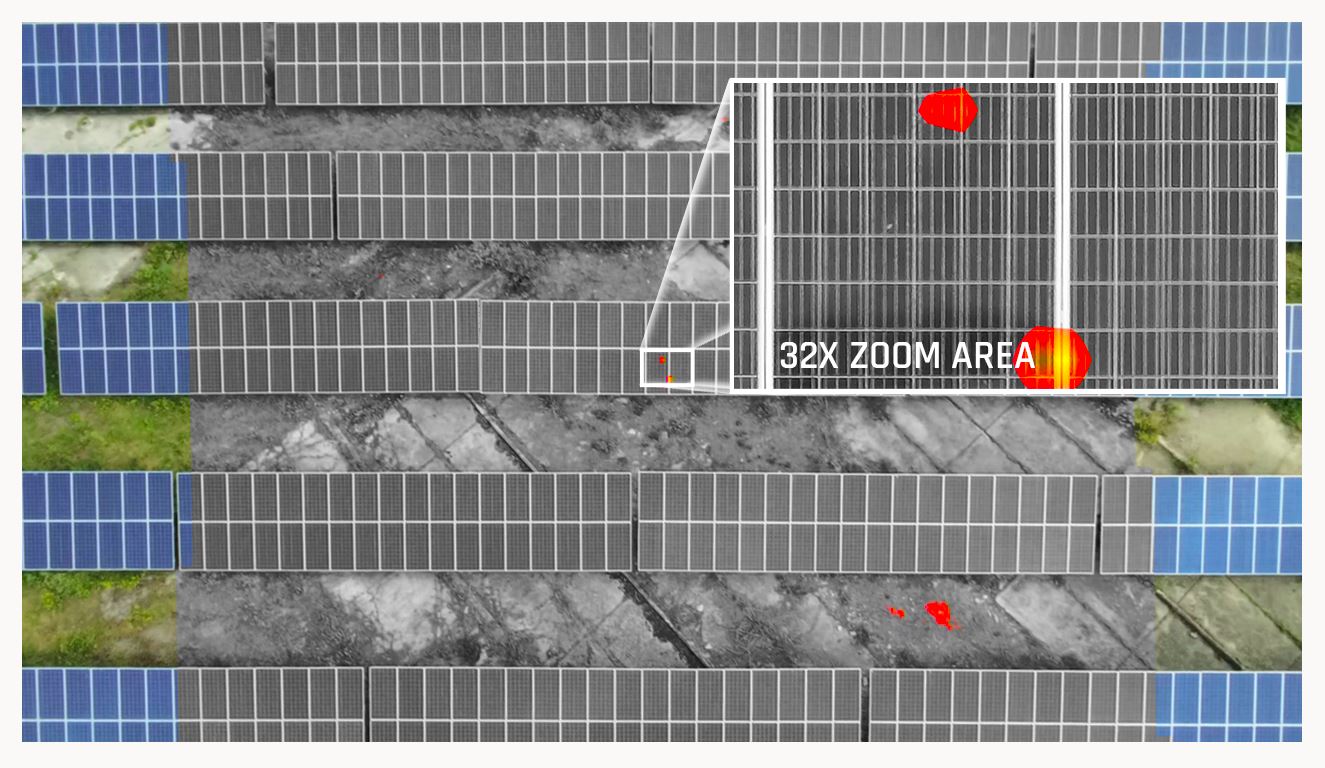
Images from the FLIR camera of ANAFI USA are linked (mixed) with the zoom image. This allows operators to view individuals and other essential details from up to 2 km (1.2 mi) away using the vision camera and to detect hot spots with the thermal camera.
The drone is flying over solar panels in the sample image below at a height of 40 meters (44 yards). The pilot can identify centimetric hot areas on the solar panels because to ANAFI USA’s strong zoom.
A particularly sensitive technological accomplishment is ensuring great image stabilization on 32x zoom images with a lightweight drone (500 g/1.1 lbs). Parrot achieved this by combining full 3-axis digital stabilization through image processing with gimbal stabilization.
Parrot Anafi USA GOV Edition Drone – EASY TO OPERATE
Rapid drone deployment is essential for first responders and the most exacting professional users during missions. In less than 55 seconds, ANAFI USA is up and running. In that time, the drone is unfolded, powered on, a secure radio link is established, and it takes off.
Without the need for GPS, ANAFI USA operates indoors, enabling users to launch the drone from within a building, guide it outside via a window, and return. To make it even more user-friendly, ANAFI USA can also take off like a paper airplane from the palm of your hand.
First responders may fly responsibly whenever and wherever their duties take them, thanks to ANAFI USA, which has no built-in restrictions for no-fly zones. At just 79 dB when it is 50 cm off the ground, ANAFI USA is the quietest drone in its class. It is easy to use and requires a regular USB-C type charger.
The small and lightweight ANAFI USA folds up effortlessly for optimal portability, weighing a mere 500 g (1.1 lb). The 32-minute flight time of ANAFI USA, despite its small size, is best in class for a drone of this size.
Reliable and safe, Anafie USA prioritizes security for its professional users.
On its SD card, pictures and movies are secured using the 512-bit key length AES-XTS method. The Secure Digital (SD) card encryption function from ANAFI USA makes sure that stored data cannot be accessed in the event that the drone or SD card are stolen or lost. Data encrypted cannot be decrypted without the decryption key.
Additionally, ANAFI USA offers a secure WPA2 Wi-Fi connection. WPA2 offers encryption and authentication for the connection between ANAFI USA and the remote controller.
The drone software cannot be maliciously altered thanks to signed firmware.
To guarantee the highest level of interoperability and security for all recorded data, Parrot employs open protocols and trusted standards, including Wi-Fi, WPA2, RTP/RTSP, H.264, and GUTMA.
Using the Free Flight 6 app, users can opt in to share data. By default, no data is shared without the user’s permission. In addition to local copies of the data on the drone, flight data and logs are saved on safe servers in Europe once the capability is enabled. The General Data Protection Regulation (GDPR) of the European Union is fully complied with by the characteristics of the drone.
NEW FLIGHT FEATURES
The sophisticated flying features offered by ANAFI USA are made to specifically cater to business drone users’ requirements. Pilots can choose from a variety of simple flight options thanks to Parrot’s highly regarded FreeFlight 6 piloting software. The flight routes of ANAFI USA can be operated independently or by coordinates in assisted framing.
The entire team can complete missions more easily because of the ability to build a flight plan with pre-set automatic flights and target tracking. The drone’s modifiable “Return to Home” (RTH) function enables users to program a designated “home” position for simple mission completion. To safeguard your company’s investment, this RTH feature activates automatically when the drone disconnects or runs low on batteries.
In order to assist operation leaders on the ground in rapidly locating targets like missing people or dangerous objects, ANAFI USA records the precise GPS coordinates of the drone and the point of interest.
SOFTWARE ECOSYSTEM for Parrot Anafi USA GOV Edition Drone
First responders may instantly convert pictures into accurate 2D maps on a laptop using ANAFI USA, which is compatible with the top mapping program Pix4Dreact.
ANAFI USA supports an expanding ecosystem of professional applications and services, including Planck AeroSystems (autonomous landing on a moving vehicle), Drone Sense (comprehensive drone management platform enabling public safety organizations to build, manage, and scale their unmanned aircraft programs), Survae (smart searching and visualization platform connecting video, images, and sensor data to interactive maps and timelines), Drone Logbook (compliance and fleet management), Kittyhawk (compliance and security for enterprise UAS fleet and airspace management), and Skyward, A Verizon company (aviation management platform, including airspace, LAANC access, as well as training, hardware, and connectivity for enterprise drone.
In the upcoming months, more partners are putting a lot of effort into joining the ecosystem, elevating ANAFI USA to the status of a professional platform of reference.
A DAY AND NIGHT IMPROVED SITUATIONAL AWARENESS EO/IR SYSTEM
- An EO (electro-optical) tele-camera with a CMOS 1/2.4-inch sensor allows for x32 stable zoom and covert surveillance capabilities.
- A longwave infrared (LWIR) thermal camera, FLIR Boson® 320: resolution of 320×256, temperature range of -10° to +150°C, and 50° HFOV
- For visible spectrum short range reconnaissance, an EO wide camera with a CMOS 1/2.4-inch sensor is used. It records both visible and thermal images and videos, with the ability to capture up to 4K HDR in visible light and 1280x720p in thermal spectrum.
- Use the device to replay, edit, and analyze thermal footage from the drone without downloading
- Three-axis hybrid stabilization consisting of two mechanical stabilization axes and three digital axes
- The gimbal tilt range is +110° (above zenith) to -140° (beyond nadir).

- Complete media and disk encryption using AES 512 bits to ensure total data security in the event of loss or theft
- WPA2-encryption and authentication for connections
Users maintain complete control over their information. - Flight data anonymization is kept on safe European servers (if shared by user).
A SMALL, RUGGY ALL-MISSION PLATFORM
IP53 APPROVED FOR RAIN AND DUST FLYING, ULTRA-PORTABLE, QUICK TO LEAVE IN SECOND
- IP53 certified (5 against solids: dust protected / 3 against liquids: sprayed water and rain protected)
- Flies in winds up to 14,7 m/s
- Each battery flies ANAFI USA 32 min
- Takes as little as 2h to charge
- Deployed and stored in under a minute
STRONG, dependable, and precise
COMPLETE WITH MISSION-SPECIFIC FEATURES, PART OF THE ROBUST FREEFLIGHT 6 ECOSYSTEM
- Powered by the well regarded piloting program FreeFlight 6 from ANAFI
- Navigate using coordinates for fully autonomous or aided framing flights: provide the satellite navigation coordinates for landing sites, waypoints, and points of interest (GPS, GLONASS, GALILEO).
- AI machine learning and a proprietary deep neural network enable visual tracking.
- Direct scene coordinate reading on screen
On the map, drag and drop an RTH location.
Simple to use interface for Pix4Dreact and Pix4Dcapture (quick offline 2D mapping) solutions
Specifications
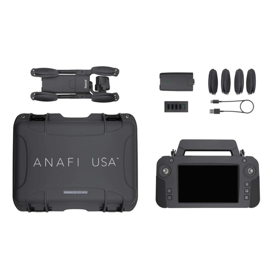
Pack content
- 1 ANAFI USA drone
- 3 smart batteries (3×32 minutes)
- 1 Skycontroller USA with its 8-inch display
- 1 multi-port fast USB charger
- 1 Skycontroller USA charger
- 1 additional set of propeller blades
- 3 USB-A/USB-C cables
- 1 USB-C/USB-C cable
- 1 hard case
Certifications
- IP53 certified (dust and rain resistant)
- NDAA & TAA compliant
- Blue sUAS program approved
Additional features
- Software-unlock maximum ascent speed: 6 m/s
- Disable the LED Lights
- Customize or disable the auto-RTH function to maximize airtime and range
- Import KML and TMS map tiles for up-to-date and optimal situational awareness
- Share precise co-ordinates
- Take off / land from the hand
- Take off from a moving vehicle or vessel
- External antenna connection for in-vehicle user environments
- Cursor on Target feature: indicates the coordinates and location of a point targeted on the screen
- RJ45 / LAN port on Skycontroller USA
Parrot Anafi USA GOV Edition Drone
FAQ's
What distinguishes the Parrot Anafi USA Gov Edition from the standard Anafi USA? The Gov Edition is tailored for government and defense use, featuring enhanced security measures, including secure data encryption and transmission, making it suitable for sensitive missions. It also includes specific functionalities and accessories designed for tactical operations.
Can the Parrot Anafi USA Gov Edition operate in GPS-denied environments? Yes, the Anafi USA Gov Edition is equipped to maintain stable flight and navigation in GPS-denied environments, leveraging its advanced sensors and flight stability systems to ensure reliability in complex scenarios.
What are the imaging capabilities of the Parrot Anafi USA Gov Edition? It maintains the high-end imaging capabilities of the standard Anafi USA, including 4K HDR video, 32x zoom, dual thermal and visual sensors, and night vision capabilities, making it ideal for surveillance, reconnaissance, and inspection.
Is the Parrot Anafi USA Gov Edition drone secure for confidential missions? Absolutely, it features end-to-end encryption for both stored data and communications, ensuring all footage, photos, and telemetry remain confidential and secure from unauthorized access.
How does the Parrot Anafi USA Gov Edition perform in adverse weather conditions? Designed with ruggedness in mind, it operates effectively in a wide range of weather conditions, including wind and rain, ensuring operational readiness for government and defense users in nearly any environment.
What is the flight time of the Parrot Anafi USA Gov Edition? The Gov Edition boasts an extended flight time, enabling prolonged missions and reducing the need for frequent battery changes, which is crucial for extended surveillance or operational missions.
How does the Parrot Anafi USA Gov Edition support night operations? It is equipped with enhanced night vision capabilities, allowing for clear imaging and human detection at significant distances even in total darkness, supporting nocturnal surveillance and search and rescue missions.
Can the Parrot Anafi USA Gov Edition be used for search and rescue missions? Yes, its thermal imaging capabilities, long-range zoom, and night vision make it an invaluable asset for search and rescue operations, helping teams locate individuals in challenging conditions and terrains.
What kind of data security measures are in place for the Parrot Anafi USA Gov Edition? It incorporates state-of-the-art encryption for data storage and transmission, alongside secure booting and firmware integrity checks, ensuring operational data integrity and security at all times.
Is the Parrot Anafi USA Gov Edition easy to deploy and operate? Yes, it is designed for quick deployment and user-friendly operation, even in the field, making it accessible for all levels of drone pilots within government and defense sectors, ensuring immediate operational capability.
The full sheet
Related products
-
·XBM·00
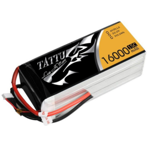
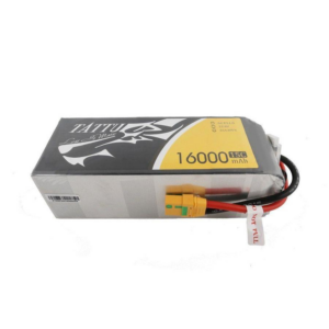 Tattu 16000mAhOriginal price was: ₹21,822.₹19,599Current price is: ₹19,599. (Excl. GST)Add to cart
 -
·XBM·01
-
·XBM·02
 VFLYX series VT01Original price was: ₹1,428,571.₹1,380,952Current price is: ₹1,380,952. (Excl. GST)Add to cart
 -
·XBM·03

There are no reviews yet.