
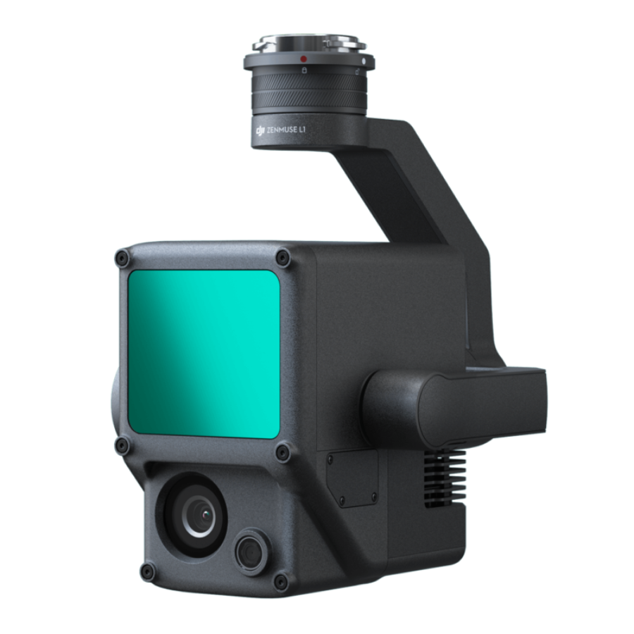
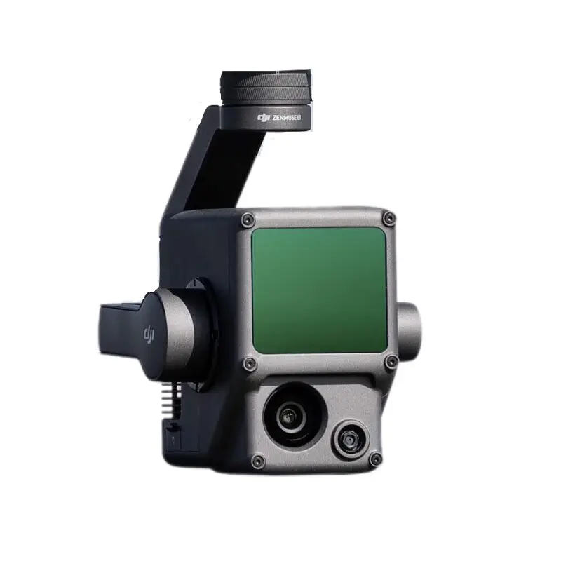
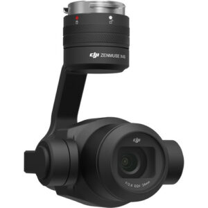
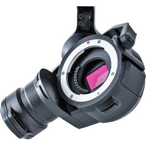
Zenmuse L1 – LiDAR Camera
- Ranging Accuracy (RMS 1σ)2: 3 cm @ 100 m
- Maximum Returns Supported: 3
- Scan Modes: Non-repetitive scanning pattern, Repetitive scanning pattern
- Sensor Size: 1 inch
- Effective Pixels: 20 MP
- Typical: 30 W; Max: 60 W
- IP Rating – IP54
- Supported Aircraft – Matrice 300 RTK/Matrice 350 RTK
- 3 months · ₹180,791
- 6 months · ₹90,396
- 9 months · ₹60,264
Select Snapmint at checkout · Available on orders above ₹3,000 · Subject to eligibility
- Trusted dealerDirect manufacturer partnership
- Pan-India deliveryInsured shipping, all states
- Post-sale supportTraining + service included
What makes it work
Zenmuse L1 Lidar
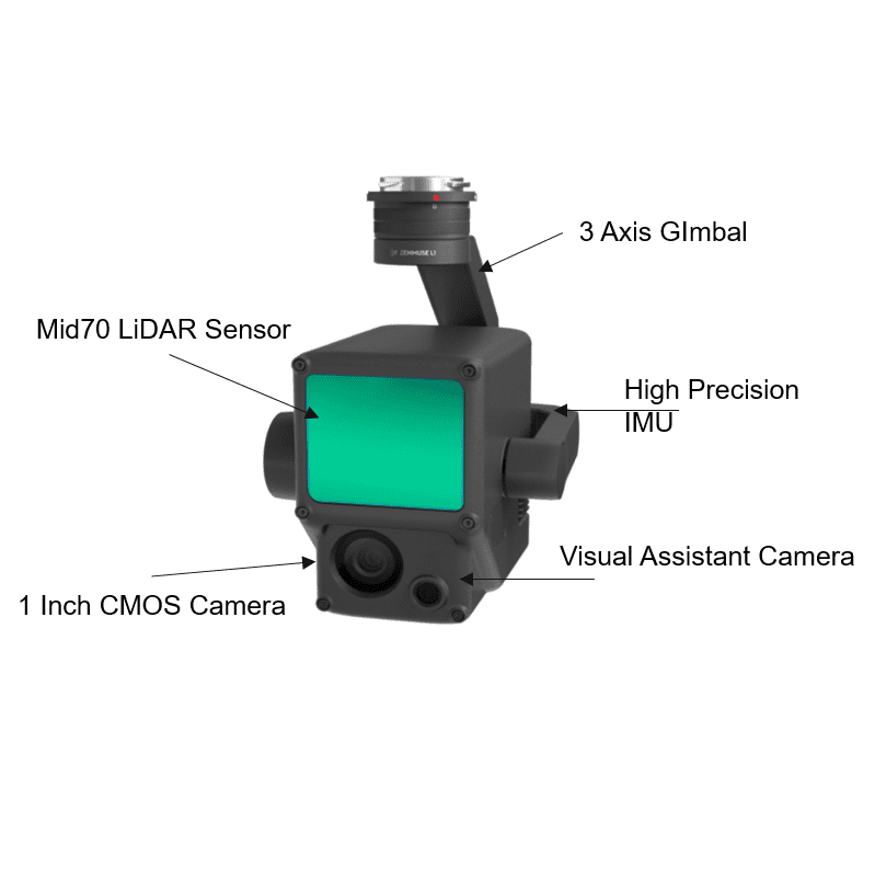
The Zenmuse L1 integrates a Livox Lidar module, a high-accuracy IMU, and a camera with a 1-inch CMOS on a 3-axis stabilized gimbal. When used with Matrice 300 RTK and DJI Terra, the L1 forms a complete solution that gives you real-time 3D data throughout the day, efficiently capturing the details of complex structures and delivering highly accurate reconstructed models.
The DJI Zenmuse L1 stands as a pioneering integration of lidar and RGB technologies, meticulously designed to cater to a wide range of applications such as surveying, construction, and agriculture, among others. Here’s an expanded overview of its features:
Advanced Lidar Module Integration: At its core, the L1 features a sophisticated Livox lidar module that excels in capturing high-fidelity three-dimensional environmental data. This capability enables users to conduct precise and detailed mappings of complex terrains and structures, facilitating a deeper understanding of the surveyed areas.
High-Resolution RGB Camera: Accompanying the lidar module is a high-resolution RGB camera that captures vivid, true-to-life color images. This feature is essential for generating colorized point clouds and photorealistic models, providing a rich visual context to the structural data captured by the lidar sensor.
High-Accuracy IMU Integration: The inclusion of a high-precision Inertial Measurement Unit (IMU) enhances the system’s ability to accurately track and record the drone’s movements in real-time. This integration significantly improves the overall accuracy of the data collected, ensuring reliable and consistent results.
️ Robust GNSS Module for Precise Geotagging: Equipped with a Global Navigation Satellite System (GNSS) module, the L1 guarantees precise geolocation tagging of lidar data, a critical aspect for mapping and surveying applications that demand high positional accuracy.
️ Designed for All-Weather Performance: The L1 is engineered to withstand various environmental conditions, making it a resilient tool for data collection in challenging weather scenarios, thereby ensuring operational continuity and data reliability.
Comprehensive 360-Degree Environmental Data Capture: Thanks to its lidar sensor’s 360-degree coverage, the L1 is capable of capturing exhaustive environmental data without leaving any blind spots, ensuring a complete and accurate representation of the surveyed area.
Secure Data Transmission Protocols: The system is designed with advanced data transmission security measures, safeguarding sensitive information during the collection and transmission of critical mission data.
Real-Time Point Cloud Visualization: A standout feature is the Point Cloud LiveView, which provides operators with a real-time visualization of point cloud data during flight operations. This immediate feedback allows for on-the-spot insights and decision-making, enhancing mission efficiency.
Seamless DJI Terra Software Integration: The L1 is fully compatible with DJI Terra, DJI’s proprietary data processing software. This compatibility streamlines the post-flight data processing workflow, enabling the efficient generation of detailed 3D models and comprehensive accuracy reports.
User-Friendly Quick-Release Design: Featuring a practical quick-release design, the L1 can be easily attached to or detached from compatible DJI drones. This design facilitates swift deployment and enhances the versatility of the payload across various missions and applications.
Enhanced Night Operation Capabilities: The L1 is adept at capturing high-quality data in low-light conditions, expanding the operational capabilities of users to conduct night-time surveys and inspections.
Broad Application Spectrum: From surveying and construction to agriculture, the Zenmuse L1 provides professionals across industries with a dynamic tool for capturing detailed environmental data, supporting informed decision-making and enhancing project outcomes.
The Zenmuse L1 embodies DJI’s commitment to innovation in aerial surveying technology, offering an unmatched blend of lidar and RGB imaging capabilities that set a new standard for accuracy, efficiency, and versatility in professional aerial data collection.
Measurement and Annotation
The capability to acquire and communicate critical dimensions directly within the point cloud model significantly enhances the precision and clarity of spatial data analysis. By utilizing measurements and annotations, users can not only determine the exact dimensions of objects and spaces within the model but also effectively convey this information through detailed notes and markers. This process not only streamlines workflow by allowing for the direct application of analytical data but also facilitates clear communication among team members or stakeholders, ensuring everyone has access to accurate, actionable insights. Such functionality is indispensable in fields like construction, architecture, and urban planning, where precise measurements are crucial for project success.
Point Cloud Live View
The advent of real-time point cloud technology marks a significant leap forward in operational efficiency and decision-making capabilities on-site. This innovation allows operators to gain instant insights into the surveyed area, equipping them with the necessary information to make pivotal decisions swiftly and with confidence. Additionally, the ability to verify the quality of fieldwork instantaneously by examining point cloud data right after a flight ensures that any necessary adjustments or re-flights can be identified and implemented promptly. This immediate feedback loop not only enhances the accuracy and reliability of the data collected but also significantly streamlines project workflows, reducing delays and improving overall project outcomes.
Specifications
General
| Dimensions | 152×110×169 mm |
|---|---|
| Weight | 930±10 g |
| Power | Typical: 30 W; Max: 60 W |
| IP Rating | IP54 |
| Supported Aircraft | Matrice 300 RTK/Matrice 350 RTK |
| Operating Temperature Range | -20° to 50° C (-4° to 122° F) 0° to 50° C (32° to 122° F) (when using RGB mapping camera) |
| Storage Temperature Range | -20° to 60° C (-4° to 140° F) |
System Performance
| Detection Range |
450 m @ 80% reflectivity, 0 klx ; 190 m @ 10% reflectivity, 100 klx |
|---|---|
| Point Rate |
Single return: max. 240,000 pts/s ; Multiple return: max. 480,000 pts/s |
| System Accuracy(RMS 1σ) |
Horizontal: 10 cm @ 50 m; Vertical: 5 cm @ 50 m |
| Real-time Point Cloud Coloring Modes |
Reflectivity, Height, Distance, RGB |
Auxiliary Positioning Vision Sensor
| Resolution |
1280×960 |
|---|---|
| FOV |
95° |
RGB Mapping Camera
| Sensor Size |
1 inch |
|---|---|
| Effective Pixels |
20 MP |
| Photo Size |
5472×3078 (16:9); 4864×3648 (4:3); 5472×3648 (3:2) |
| Focal Length |
8.8 mm / 24 mm (Equivalent) |
| Shutter Speed |
Mechanical Shutter Speed: 1/2000 – 8 s Electronic Shutter Speed: 1/8000 – 8 s |
| ISO |
Video: 100 – 3200 (Auto), 100 – 6400 (Manual) Photo: 100 – 3200 (Auto), 100 – 12800 (Manual) |
| Aperture Range |
f/2.8 – f/11 |
| Supported File System |
FAT (≤32 GB); exFAT (>32 GB) |
| Photo Format |
JPEG |
| Video Format |
MOV, MP4 |
| Video Resolution |
H.264, 4K: 3840×2160 30p |
Lidar
| Ranging Accuracy (RMS 1σ) | 3 cm @ 100 m |
|---|---|
| Maximum Returns Supported | 3 |
| Scan Modes | Non-repetitive scanning pattern, Repetitive scanning pattern |
| FOV | Non-repetitive scanning pattern: 70.4° (horizontal) × 77.2° (vertical) ; Repetitive scanning pattern: 70.4° (horizontal) × 4.5° (vertical) |
| Laser Safety | Class 1 (IEC 60825-1:2014) (Eye Safety) |
Inertial Navigation System
| IMU Update Frequency |
200 Hz |
|---|---|
| Accelerometer Range |
±8 g |
| Angular Velocity Meter Range |
±2000 dps |
| Yaw Accuracy(RMS 1σ) |
Real-time: 0.3°, Post-processing: 0.15° |
| Pitch / Roll Accuracy(RMS 1σ) |
Real-time: 0.05°, Post-processing: 0.025° |
Data Storage
| Raw Data Storage |
Photo/IMU/Point cloud data storage/GNSS/Calibration files |
|---|---|
| Supported microSD Cards |
microSD: Sequential writing speed 50 MB/s or above and UHS-I Speed Grade 3 rating or above; Max capacity: 256 GB |
| Recommended microSD Cards |
SanDisk Extreme 128GB UHS-I Speed Grade 3 SanDisk Extreme 64GB UHS-I Speed Grade 3 SanDisk Extreme 32GB UHS-I Speed Grade 3 SanDisk Extreme 16GB UHS-I Speed Grade 3 Lexar 1066x 128GB U3 Samsung EVO Plus 128GB |
Post-processing Software
| Supported Software |
DJI Terra |
|---|---|
| Data Format |
DJI Terra supports exporting standard format point cloud models: Point cloud format: PNTS/LAS/PLY/PCD/S3MB format |
Read More
The Zenmuse L1 LiDAR camera marks a significant advancement in aerial surveying technology, providing professionals with an unprecedented level of data accuracy and spatial awareness. Available on xboom.in, this cutting-edge LiDAR system integrates seamlessly with DJI’s drone platforms, making it an essential tool for geospatial professionals, engineers, and environmental scientists seeking to capture detailed topographical information with efficiency and precision.
Elevating Geospatial Data Collection
The Zenmuse L1 LiDAR is not merely a camera; it’s a comprehensive solution for aerial data collection that combines high-precision LiDAR technology with a powerful RGB camera and a highly accurate IMU. This integration enables the Zenmuse L1 LiDAR to capture dense point clouds and vivid imagery simultaneously, offering a holistic view of surveyed areas that is unparalleled in the industry.
Why Choose the Zenmuse L1 LiDAR?
Opting for the Zenmuse L1 LiDAR means selecting a tool designed for the future of aerial surveying. Its LiDAR sensor can penetrate dense vegetation, providing accurate topographical data even in challenging environments. This capability makes it invaluable for applications ranging from forestry management and environmental monitoring to urban planning and construction.
Precision and Efficiency in One Package
At the core of the Zenmuse L1 LiDAR’s capabilities is its exceptional precision. The device offers a point rate of 240,000 pts/s and a detection range of 450m, ensuring comprehensive coverage and detailed data collection over large areas. Coupled with its high-efficiency workflow, the Zenmuse L1 LiDAR significantly reduces the time and cost associated with traditional surveying methods.
Unmatched Versatility in Aerial Imaging
The Zenmuse L1 LiDAR redefines versatility with its ability to be mounted on DJI’s Matrice 300 RTK, offering users unparalleled control and flexibility in their aerial imaging endeavors. This compatibility ensures that the Zenmuse L1 LiDAR can be adapted to various missions, making it suitable for a wide range of industries and applications.
Streamlined Data Processing Workflow
Integrating the Zenmuse L1 LiDAR into your workflow is seamless, thanks to its compatibility with DJI Terra and other post-processing software. This streamlined process allows for the efficient transformation of raw LiDAR data into actionable insights, enabling professionals to analyze and utilize the collected data effectively.
Revolutionizing Multiple Industries
The Zenmuse L1 LiDAR is poised to revolutionize various industries by providing detailed and accurate geospatial data that supports decision-making and innovation. From enhancing agricultural practices through precise terrain analysis to improving public safety with detailed environmental assessments, the Zenmuse L1 LiDAR opens up new possibilities for analysis and planning.
Why xboom.in is Your Ideal Source
Choosing xboom.in for your Zenmuse L1 LiDAR purchase not only guarantees a competitive price but also offers the peace of mind that comes with purchasing from a trusted source. xboom.in is committed to providing customers with authentic DJI products, expert support, and comprehensive service, ensuring that you have everything you need to succeed with the Zenmuse L1 LiDAR.
A Future-Proof Investment
Investing in the Zenmuse L1 LiDAR is an investment in the future of aerial surveying. As the demand for more accurate and efficient geospatial data collection methods continues to grow, the Zenmuse L1 LiDAR stands ready to meet these challenges, providing users with a tool that will remain valuable and relevant for years to come.
Conclusion: Charting New Territories with Zenmuse L1 LiDAR
The Zenmuse L1 LiDAR, available on xboom.in, represents a breakthrough in aerial surveying technology. With its unparalleled precision, efficiency, and versatility, it offers professionals a new level of capability and flexibility in capturing geospatial data. Whether for mapping, surveying, or environmental monitoring, the Zenmuse L1 LiDAR is a game-changer, empowering users to chart new territories and gain deeper insights into the world around us.
Explore the future of aerial LiDAR technology with the Zenmuse L1 LiDAR. Visit xboom.in today and discover how this revolutionary tool can transform your projects and elevate your professional capabilities.
FAQ’s on Zenmuse L1
FAQ's
What is the Zenmuse L1, and what does it do? The Zenmuse L1 is a lidar + RGB camera payload developed by DJI, designed for use with the Matrice 300 RTK drone. It integrates a Livox lidar module, a high-precision IMU, a GNSS module, and a high-resolution RGB camera to capture detailed three-dimensional data and images for advanced mapping, surveying, and inspection tasks.
What types of applications is the Zenmuse L1 suitable for? The Zenmuse L1 is ideal for a wide range of applications, including but not limited to precision agriculture, topographic mapping, forestry management, construction monitoring, and infrastructure inspection, thanks to its ability to generate accurate 3D models and capture high-quality images.
How accurate is the lidar data captured by the Zenmuse L1? The Zenmuse L1, equipped with the Livox lidar module and high-precision IMU, captures highly accurate three-dimensional point cloud data. When combined with the Matrice 300 RTK and DJI Terra software, it can achieve centimeter-level accuracy in its spatial data collection.
Can the Zenmuse L1 operate in low-light conditions? Yes, the Zenmuse L1’s RGB camera is capable of capturing high-quality images in low-light conditions, complemented by the lidar’s ability to collect data regardless of lighting conditions, making it suitable for operations during twilight hours or in shaded areas.
What is the maximum range of the laser rangefinder in the Zenmuse L1? The laser rangefinder in the Zenmuse L1 can measure distances up to 1,200 meters, providing valuable data for measuring features in the environment accurately and planning missions accordingly.
How does the Zenmuse L1 integrate with DJI drones and software? The Zenmuse L1 is specifically designed for seamless integration with the DJI Matrice 300 RTK drone, offering easy attachment and compatibility. For data processing, it works flawlessly with DJI Terra software, enabling users to process the captured lidar and image data into accurate 3D models and maps.
Is the Zenmuse L1 weather-resistant? Yes, the Zenmuse L1 is built to withstand various environmental conditions, making it a reliable tool for outdoor operations across different weather scenarios.
Can the Zenmuse L1 capture data over large areas? Absolutely, the Zenmuse L1 is capable of capturing data over large areas efficiently, thanks to its high-speed lidar module and the extended flight capabilities of the Matrice 300 RTK, making it an excellent choice for surveying large plots of land or monitoring extensive infrastructure projects.
The full sheet
Related products
-
·XBM·00
-
·XBM·01
 Battery Charger – Phantom 4 SeriesOriginal price was: ₹6,694.₹6,609Current price is: ₹6,609. (Excl. GST)Add to cart
 -
·XBM·02
Out of stock
-
·XBM·03
 DJI Motion controllerOriginal price was: ₹21,186.₹12,033Current price is: ₹12,033. (Excl. GST)Add to cart

There are no reviews yet.