

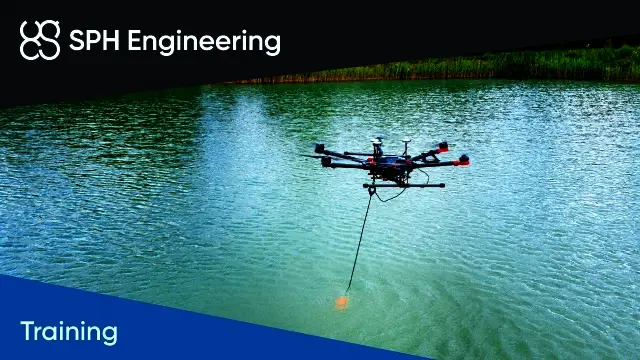
Bathymetric Data Collection using Drones (BATHY-1)
- Only one of its kind training for bathymetric surveys with echo sounders integrated with a drone
- Covers safety for flights over water, system assembly and system parameters setup
- Includes planning the survey grid, Grasshopper mode for bathymetric surveys and quality control with control lines
- Up to 4 hours for a group of up to 4 students
- Provided at the SPH Engineering office or using video conferencing software
- Prerequisite: UgCS AreaScan and TTF training (or equivalent) and a True Terrain Following test flight over the ground
- Trusted dealerDirect manufacturer partnership
- Pan-India deliveryInsured shipping, all states
- Post-sale supportTraining + service included
What makes it work
Bathymetric Data Collection using Drones (BATHY-1)
Only one of its kind training to learn how to perform bathymetric surveys with echo sounders integrated with a drone.
The course can be provided at the SPH Engineering office or using video conferencing software.

Course Highlights
Learn the complete workflow for bathymetric surveys with a drone-integrated echo sounder, from safety to quality control.
Safety Over Water
Safety considerations for flights over water.
Assembly and Setup
System assembly and system parameters setup (echo sounder mode, data logging formats, angles, etc.).
Survey Planning
Planning the survey grid for bathymetric surveys, and Grasshopper mode for bathymetric surveys.
Quality Control
Quality control (control lines, etc.).
Prerequisites and Delivery
Prerequisites and Test Flight
Completed UgCS AreaScan and True Terrain Following missions training or equivalent knowledge and experience.
The trainee has to perform a True Terrain Following mission test flight over the ground in a safe and controlled environment.
Remote review of telemetry and SkyHub positioning log files will be performed at the beginning of the session.
If a trainee can't demonstrate results of completed missions, the trainer will cancel the training session, and it has to be rescheduled.
Delivery
- At the SPH Engineering office
- Using video conferencing software
Training Outline
- Safety considerations for flights over water
- System assembly
- System parameters setup (echo sounder mode, data logging formats, angles, etc.)
- Planning the survey grid for bathymetric surveys
- Grasshopper mode for bathymetric surveys
- Quality control (control lines, etc.)
Specifications
| Product | Trainer-led course - Bathymetric Data Collection using Drones (BATHY-1) |
|---|---|
| Brand | SPH Engineering |
| SKU | IS-TRAINING-BATHY-1 |
| Type | Course |
| Delivery | At the SPH Engineering office or using video conferencing software |
| Duration | Up to 4 hours |
| Group size | Up to 4 students |
| Prerequisites | Completed UgCS AreaScan and True Terrain Following missions training or equivalent knowledge and experience |
| Before the session | True Terrain Following mission test flight over the ground in a safe and controlled environment |
Documentation and Support
Frequently Asked Questions
What does the BATHY-1 course teach?
It teaches how to perform bathymetric surveys with echo sounders integrated with a drone.
What do I need before joining?
Completed UgCS AreaScan and True Terrain Following missions training or equivalent knowledge and experience. The trainee also has to perform a True Terrain Following mission test flight over the ground in a safe and controlled environment.
What is checked at the start of the session?
A remote review of telemetry and SkyHub positioning log files is performed at the beginning of the session. If a trainee cannot demonstrate results of completed missions, the trainer will cancel the training session, and it has to be rescheduled.
How long is the course and how many students can join?
The course takes up to 4 hours and is designed for a group of up to 4 students.
How is the course provided?
It can be provided at the SPH Engineering office or using video conferencing software.


There are no reviews yet.