
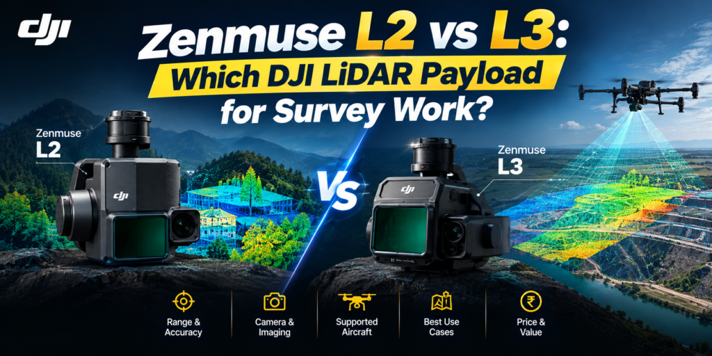
DJI now sells three aerial LiDAR payloads in India, and the newest one is not a straight upgrade of the one below it. The Zenmuse L3, announced in November 2025, sits at roughly twice the price of the L2 and will only fly on one aircraft. Before you spend the difference, it is worth being clear about what that money actually buys — and what it does not.
We sell all three, so here is the honest comparison.
The one-line answer
If you already own a Matrice 350 RTK or 300 RTK, the L2 is your only current option — the L3 will not fly on those aircraft. If you are buying an aircraft and a payload together, and your work is corridor mapping, forestry or large-area topographic survey, the L3’s extra range and 100 MP imaging change what a single flight can cover. For plot-scale work, stockpiles, and most construction progress capture, the L2 is still the sensible tool.
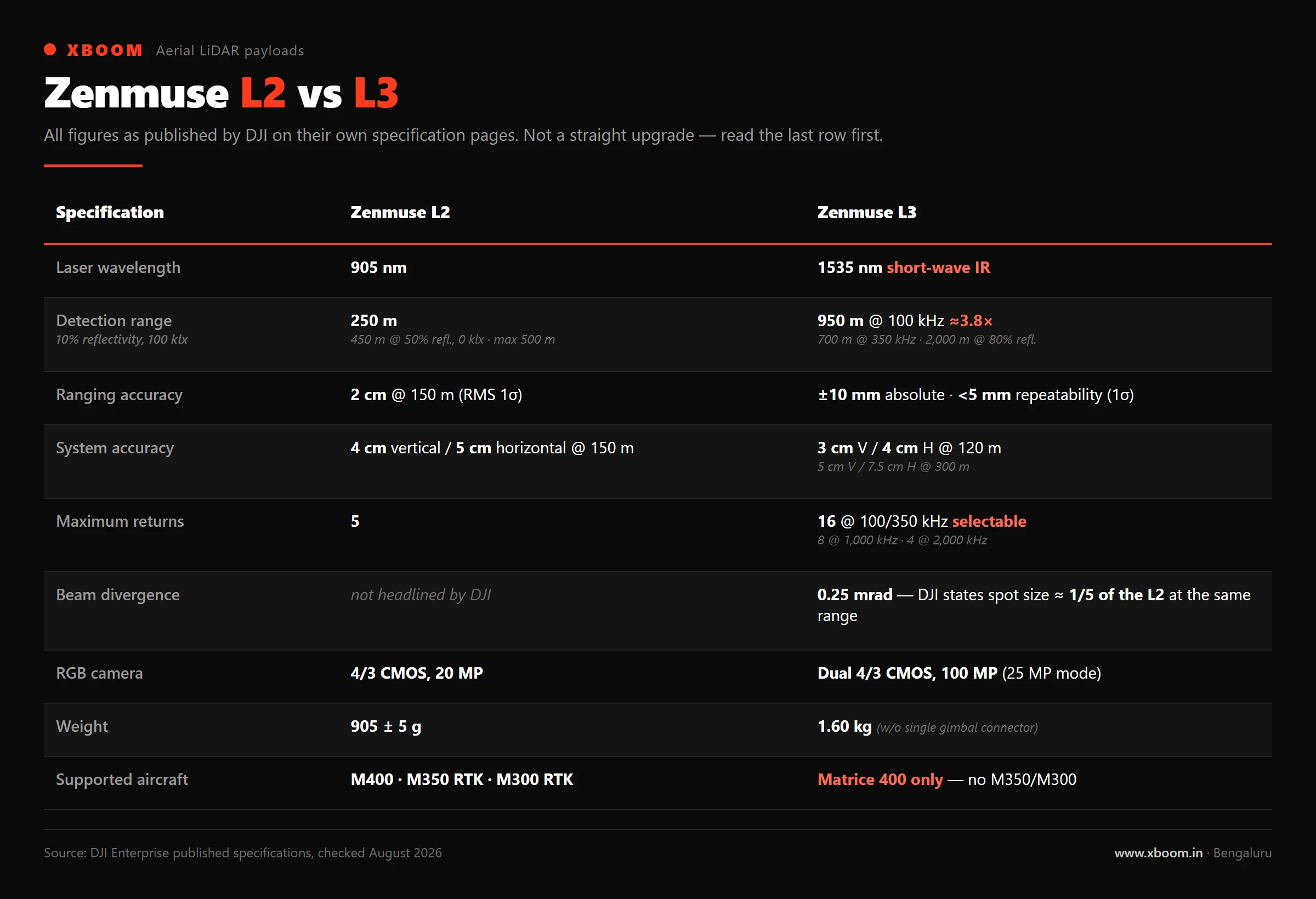
All figures below are from DJI’s own published specification pages for each payload.
| Zenmuse L1 | Zenmuse L2 | Zenmuse L3 | |
|---|---|---|---|
| Laser wavelength | 905 nm | 905 nm | 1535 nm |
| Detection range | 450 m @ 80% reflectivity, 0 klx; 190 m @ 10% reflectivity, 100 klx | 250 m @ 10% reflectivity, 100 klx · 450 m @ 50%, 0 klx · max 500 m | 950 m @ 10% reflectivity, 100 kHz · 700 m @ 10%, 350 kHz · 2,000 m @ 80%, 100 kHz |
| Ranging accuracy | 3 cm @ 100 m (RMS 1σ) | 2 cm @ 150 m (RMS 1σ) | Absolute ±10 mm · repeatability < 5 mm (1σ) |
| System accuracy | Horizontal: 10 cm @ 50 m; Vertical: 5 cm @ 50 m | 4 cm vertical / 5 cm horizontal @ 150 m | 3 cm vertical / 4 cm horizontal @ 120 m · 5 cm / 7.5 cm @ 300 m |
| Max returns | 3 | 5 | 16 (at 100/350 kHz), 8 (1,000 kHz), 4 (2,000 kHz) |
| Point rate | 240,000 points/s (single return); up to 480,000 points/s (multiple return) | 240,000 pts/s single return · 1,200,000 pts/s multiple | Point rate selectable 100 kHz – 2 MHz |
| Beam divergence | 0.28° vertical × 0.03° horizontal | Horizontal 0.2 mrad, Vertical 0.6 mrad (FWHM) | 0.25 mrad (1/e²) |
| RGB camera | 1-inch, 20 MP | 4/3 CMOS, 20 MP | 4/3 CMOS, 100 MP (also 25 MP mode) — dual cameras |
| Field of view | 70.4° horizontal × 77.2° vertical — non-repetitive scanning; 70.4° × 4.5° — repetitive scanning | 70° × 3° repetitive · 70° × 75° non-repetitive | 80° × 3° linear · 80° × 80° star-shaped and non-repetitive |
| Weight | 930 ± 10 g | 905 ± 5 g | 1.60 kg (without single gimbal connector) |
| IP rating | IP54 | IP54 | IP54 |
| Supported aircraft | Matrice 300 RTK / Matrice 350 RTK | Matrice 400 · Matrice 350 RTK · Matrice 300 RTK | Matrice 400 only |
The four things that actually differ
1. Aircraft compatibility is the first filter, not the last
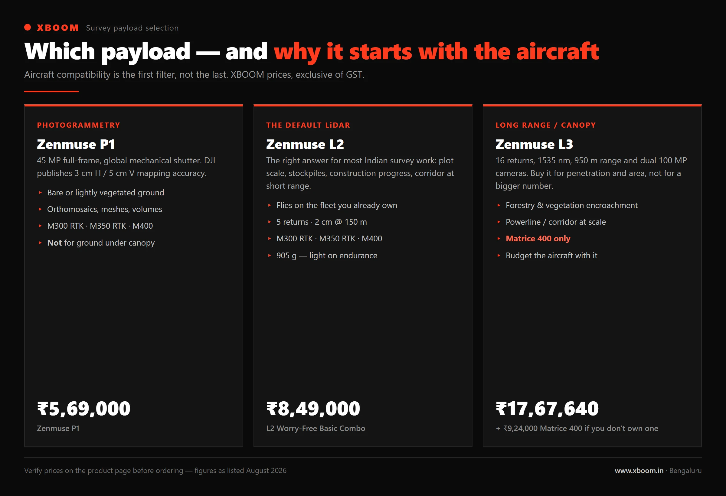
This is the decision most people get to too late. The L2 flies on the Matrice 300 RTK, 350 RTK and 400. The L3 flies on the Matrice 400 and nothing else.
If your fleet is M350 RTK, the L3 is not a payload upgrade — it is an aircraft replacement plus a payload. Budget for alongside it. We wrote about that aircraft separately in .
2. Wavelength: 905 nm vs 1535 nm
The L1 and L2 use a 905 nm laser. The L3 moves to 1535 nm, in the short-wave infrared band that long-range survey LiDAR generally uses. The practical consequence is that the L3 can push far more energy into each pulse and still stay within eye-safety limits, which is a large part of how it reaches 950 m where the L2 reaches 250 m under the same 10% reflectivity and 100 klx test conditions.
3. Beam divergence and what “one-fifth the spot size” means
DJI’s L3 announcement states that its 0.25 mrad beam divergence gives a spot size at a given range roughly one-fifth that of the Zenmuse L2.
Beam divergence is the specification that survey teams under-rate. A tighter beam means each returned point represents a smaller patch of ground. On a power line, that is the difference between resolving the conductor and resolving a fuzzy tube where the conductor is. On a forest canopy, it is the difference between a return that penetrated a gap and a return that averaged the leaf and the gap together.
If your work is corridor inspection or vegetation-encroachment mapping, this specification matters more to you than the detection range does.
4. Returns and point rate: density is now a dial
The L2 supports up to 5 returns. The L3 supports up to 16 returns at 100 and 350 kHz, and lets you trade returns against pulse rate — 8 returns at 1,000 kHz, 4 at 2,000 kHz.
That trade-off is the L3’s real design idea. You choose, per mission, between maximum penetration through vegetation (high returns, lower rate) and maximum coverage (high rate, fewer returns). The L2 does not offer that dial.
DJI states the L3 can cover up to 100 km² a day, with a single flight covering up to 10 km² at 300 m altitude at a 3 cm ground sample distance from its dual 100 MP cameras.
What it costs in India
| Payload | XBOOM price |
|---|---|
| ₹6,40,000 | |
| ₹8,49,000 | |
| ₹17,67,640 | |
| (required for the L3) | ₹9,24,000 |
Two things to read carefully in that table.
The L2 figure is for the Worry-Free Basic Combo, not the bare payload. That listing includes the payload plus the combo’s service and accessory bundle, and our product page notes three months of DJI Terra included. Prices are exclusive of GST.
The L3 line is a ₹17.67 lakh payload that requires a ₹9.24 lakh aircraft. If you do not already fly an M400, the realistic entry cost of L3-class data collection in India is closer to ₹27 lakh before GST, ground control, processing software and a pilot.
Where the P1 fits — and when LiDAR is the wrong answer
Not every survey job needs LiDAR. If your deliverable is an orthomosaic, a 3D mesh or a volumetric calculation on bare or lightly vegetated ground, photogrammetry is cheaper and often produces a better-looking product.
— a 45 MP full-frame camera with a global mechanical shutter, at ₹5,69,000 — will do that work for less than any of the LiDAR payloads above, and DJI publishes 3 cm horizontal / 5 cm vertical mapping accuracy for it.
The case for LiDAR is specific: you need ground under vegetation, you need to work in poor light or at night, you need to resolve thin linear structures like cables and pylons, or your client’s specification names a point cloud. If none of those apply, spend the money on ground control and a better processing workflow instead.
Choosing, in three questions
- What aircraft do you fly today? M350 RTK or M300 RTK, and the shortlist is L1 or L2. Buying the aircraft too, and the L3 is genuinely on the table.
- Is your ground under a canopy? If yes, returns and beam divergence decide the job, and the L3’s 16-return mode is the reason it exists. If no, the L2 or even the P1 will very likely meet your accuracy spec.
- What is the area per mobilisation? A few hundred hectares a day and the L2 is not the bottleneck — the drive to site is. Hundreds of square kilometres across a season and the L3’s coverage rate starts paying for the aircraft.
If you want to talk it through against a specific project rather than a specification sheet, our survey team does this daily — see and , or with the site and the deliverable and we will tell you which payload is enough.